Affichage des articles dont le libellé est Maps. Afficher tous les articles

lundi 6 juillet 2015

Google Wallet update brings Maps integration and keyword search


Google Wallet tap to pay phone


Google Wallet is adding a few small, but pretty worthwhile new features in the Google Play Store today. Announced on their Google+ page, Wallet won’t just tell you where you bought something, they’ll actually show you. This is done using Google Maps which has now been integrated into the app and viewable in the transaction details.


Google Wallet rich receipt Maps


Now the next feature is even more useful. Imagine it’s several weeks later and you can’t for the life of you remember where it was you had those amazing tacos during a drunken night out with your friends. You could scroll through all your transactions like an animal, keeping an eye out for anything related to Mexican eateries.


Or, like a future-man, you can simply search through your transaction history by merchant name, item of purchase, or any other keywords. Type in “bomb tacos” and you’ll pull up a transaction — now with a handy Maps location — of that amazing hole-in-the-wall.


The update should already be waiting for you in the Google Play Store, so make sure you update and happy shopping.


Google integrates My Maps with Google Maps for Android


google my maps


Google My Maps users have been frustrated that they can’t get their custom maps in Google Maps, and rightfully so. But that issue has finally been eradicated: Google has finally brought My Maps functionality to the Google Maps for Android app.


My Maps allows people to specify routes and points of interest on a map. This is useful for, say, bikers and runners who want to remember their favorite routes or share them with others, or for navigating a golf course.


You can only make My Maps on the web or with the separate My Maps app, but once you’ve gotten them loaded up they’ll be available for use in Google Maps. Be sure to give it a try!


Nokia is exploring the possibility to sell HERE Maps


nokia-logo


One of the best alternatives to Google Maps could be changing hands. Nokia has announced that it is reviewing its HERE mapping business and may even consider selling it off. Nokia’s HERE Android app has currently been downloaded over 1 million times in the Google Play Store. It’s still far behind the 1 billion downloads of the Google Maps app, but it’s still one of the better alternatives.


Nokia also has announced plans to acquire Alcatel-Lucent for .6 billion. Alcatel is the maker of many low to mid-range Android devices and accessories. We’ve covered their devices at trade shows in the past, but they don’t usually make much noise past that. The deal is mainly to solidify Nokia’s goal to become a major provider of networking equipment.


Have you ever used HERE Maps? Do you care about Alcatel being bought by Nokia?


[via Nokia (1)(2)]


T-Mobile’s next-gen coverage maps pull data from real-time customer usage


SEA_Map


T-Mobile’s strange-looking coverage maps used to be the inside joke of the wireless industry, but the company has made significant strides to improve their network in the past couple of years. With LTE, much-improved coverage, a forward-looking approach to network design and overall better network stability they’ve set themselves up for a nice future, and now they’re looking to flaunt it with their “next generation” coverage map.


The map uses crowd-sourced real-time data points to give users a clear — and, more importantly, accurate — idea of how strong T-Mobile’s network is in their area. They also use public speed test results to show you an average of the types of data speed users experience in any given area. Here’s the full breakdown of what their new coverage map brings:


  • Customer-verified coverage based on actual customer usage, resulting in a vastly more transparent and accurate map, showing, for example, exactly where you can expect 4G LTE, 4G, 3G or other levels of coverage.

  • A Verified Coverage icon indicating where the majority of data is provided by T-Mobile customers reporting their actual network experience, providing an added layer of confidence.

  • Data that’s updated twice monthly − compared to data presented on the carriers’ maps, which is already dated by the time it’s printed and published and may be months or even years old.

  • Speed test data from trusted third party apps showing average download speeds from customer speed tests over the last 90 days.


It’s nothing other apps haven’t been trying to do for years to help customers make informed decisions about finding the right carrier for them. Carrier Coverage is one app that looks to fill that need. But this is the first time a carrier has taken it upon themselves to create a coverage map based on crowd-sourced data and provide more than just pretty colors on a meaningless map. We’d love to see the other big 3 follow suit. You can check it out for your area right now by heading to T-Mobile’s coverage website here.


[via T-Mobile]


There’s a giant Android robot urinating on an Apple logo in Google Maps RIGHT NOW


google maps android pissing on apple


Quick, before Google notices: go to this Google Maps destination (make sure you’re in Map view, not Satellite view) and tell me what you see. No, it’s not the oddest-shaped golf course you’ve ever seen — it’s a picture of an Android robot urinating on an Apple logo. You know, the one we’ve seen depicted time and time again since Android’s existence.


We’re not sure who. We’re not sure why. We’re not sure how. And we’re not sure when Google will finally notice this and take it down. But it’s something you owe it to yourself to see even if you have nothing against Apple and don’t care for the everlasting feud between the two sides.


PS: Can’t click links? You can also type the coordinates in manually. Simply enter 33°30’52.5″N 73°03’33.2″E into the search box.


[Update]: Well, we can probably explain the “how” by now. It appears this may be the work of someone using Google Map Maker, a custom map-enhancing tool that allows users to submit changes, updates and enhacnements to maps of their local area for use on the public version of Google Maps.


It’s likely that someone submitted these custom maps, and a moderator simply approved them without checking to see what, exactly, the map changes consist of. Here’s a passive plea by someone who used to same method to bring about a better review policy for custom maps:


originalSo there you have it. Might want to get that taken care of, Google. [via]


[via Engadget]


Google Maps gets improved traffic alerts in time for Memorial Day


google maps


Google has detailed a new update for Google Maps that’ll help you avoid the dreadful result of a busy society: congested traffic. The company’s improved traffic alerts will now let you know if there is heavy traffic en route to your destination and will let you select an alternate route, if available.


The app will also update you on traffic conditions once you’ve already started your journey. It’ll let you know if congestion lies ahead, and — if so — will attempt to estimate how long you’ll be stuck. All of this is in preparation for the upcoming Memorial Day, though the feature will obviously stick well beyond that.


Google says the update will be in Google Play in time for the weekend so be sure to keep an eye out if you think you’ll need the future ahead of then.


[via Google]


Uber to challenge Google, hires former VP of Google Maps


Aside from Search, Google has a handful of products that command dominating strategic advantages, one of them being Google Maps. Together with Android Auto, this positions Google brilliantly to capitalize on one of the tech industries most promising yet unharvested sectors. From performing simple turn-by-turn navigation that displays relevant advertising to the futuristic but not too far reality of driverless cars, there is a lot more money to be made- and Uber wants a piece of Google’s pie.


Here is what Google Maps looked like when it was announced in 2005:


google-maps-2005


Under the direction of Brian McClendon, VP Engineering at Google, here is what it looks like 10 years later:


Google-Maps-Material-Design


Now McClendon, the man who took the Maps team from Point A to Point B, has officially joined Uber to help take their mapping efforts to the next level.


brian-mcclendon


At one point Uber was just a taxi alternative but the size and speed of the company’s growth has been astronomical. Rather than simply being a service that relies on APIs from Google Maps and Apple Maps, Uber looks to compete directly. Not only could they create their own alternative as a broad solution, but it’ll prove invaluable down the road as the companies seem headed towards an inevitable collision course in the fight for eventual self-driving car prominence.


“Google was actually Ubering before Uber”


Before you begin claiming that Google is trying to use their sheer size to eat everyone else’s lunch, let us not forget that Google was actually was Ubering before Uber, announcing Google Ride Finder way back in 2005 aside Google Maps.


It’s way too early to tell who has the upper hand, but one thing is for sure: it’ll be fun to look back in another 10 years and see how far mapping, navigation, and transportation of come in relation to these two companies.


brian-mcclendon-uber


Google Maps will soon warn you when approaching railroad crossings


google maps lane guidance


Google and the Federal Railroad Administration today announced a partnership that would help Google get information about all public and private railroad crossings in the United States. What’s the purpose for that? Safer and more accurate navigation, of course.


Having access to the entire database of railroad locations allows Google to build safety features into Google Maps that will warn you — both with visual and audible cues — when coming up to a railroad crossing. This should help people drive more cautiously at these points and cut down on railway accidents which were apparently the cause of more than 280 deaths and over 800 injuries last year.


Unfortunately there’s no timeline for the feature’s arrival, but Google should work fast enough to get the functionality into Google Maps before year’s end. In the meantime, the FRA has its own app you can use to find railroad crossings in your area to make sure you know where they are on your routes.


[via New York Times]


Google Maps adds rental car information and improved photo viewer


google maps lane guidance


Google Maps has long been one of the best features of Android. Sure, it’s also available on iOS, but there’s nothing quite like using it on an Android device. Google relentlessly adds new features and improvements to keep it on top. The latest batch of features includes rental information and a photo viewer.


If you have a rental car reservation tied to your Google account you will be able to bring up that information when searching the area. You’ll see the pick up or drop off location and reservation number. Google has also improved the photo viewer so you can see multiple photos of a location. Other improvements include a new “Your Places” screen, and the removal of “Shake to send feedback” being enabled by default.


Google Maps version 9.10 is rolling out right now. Download from Google Play.


Google adds vertical Street View to Maps starting with Yosemite’s El Capitan rock wall [VIDEO]


el capitan shot


Google Maps’ Street View feature was once reserved for the simple purpose of helping people find their way through busy city streets, but it’s changed over the years. We’ve gotten views of national landmarks, parks, inside the White House and even coral reefs underwater.


And now there are vertical views of some of the world’s biggest rocks. The team partnered with expert rock climbers Alex Honnold and Lynn Hill to deliver vertical imagery of the entire height (3,000 solid feet) of Yosemite Park’s El Capitan (and no, it has nothing to do with Apple’s latest Mac OSX update).


The views really are breathtaking, and it’s a great way to check out the exhilaration known as rock climbing without having to do it yourself, which is especially great for someone like me who is deathly afraid of extreme heights.


el capitan gif


The video above is cool and all, but you should give it a go on Google Maps for a truly neat experience. Nothing will ever come close to climbing up the real deal, of course, but this is as good as it gets otherwise.


[via Google]


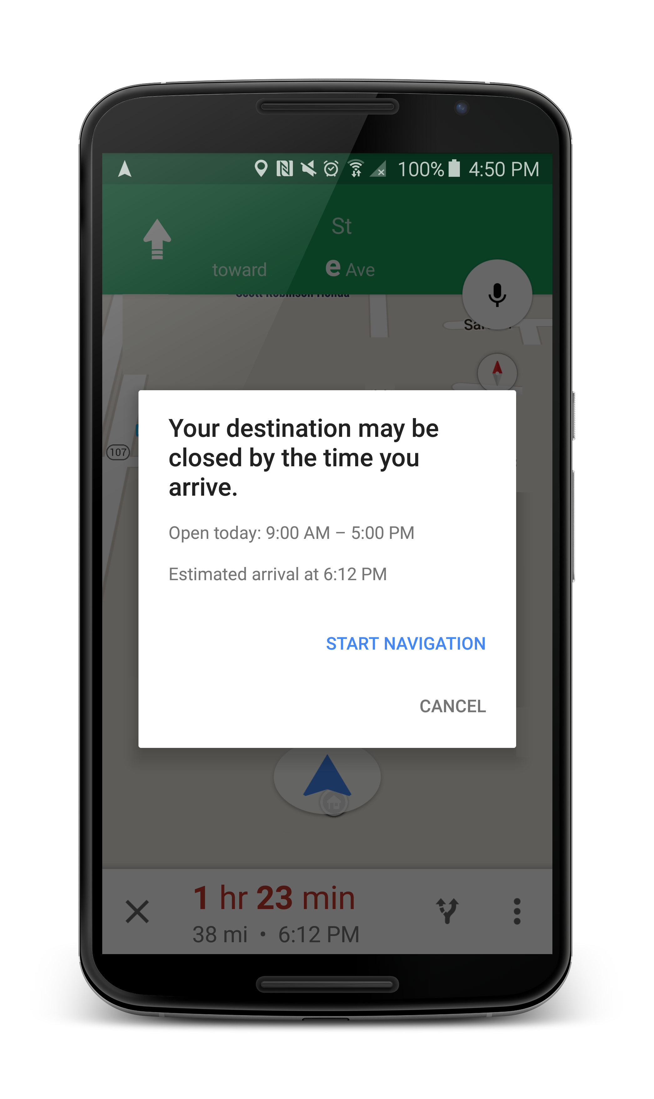
Google Maps now warns you when navigating to a business that’s already closed (or will be when you arrive)


Google Maps business hours notification navigation


An update is rolling out now to Google Maps that introduces a new feature you wont believe you’ve been able to live without. As detailed in the changelog of the app’s Play Store listing, Google Maps will now tell you when a place or business you’re navigating to is closed, or will be closed by the time you get there. How’s that for convenience?


For those unaware, Google Maps already lists business hours for most places, but sometimes this gets overlooked when you’re quickly looking up an address for navigation. On a personal note, this would have come in handy yesterday when I was running on empty and navigating to a nearby Costco for a fill up, only to find out it was one of the few locations that was actually closed on Sundays.


Oh, the update also shows car rental reservations (pulled from Gmail) in ‘my events.’ A splendid update, indeed. Thank you, Google. Sometimes it’s the little things that matter most.